• 3 min read
Mars clay deposits near ExoMars look like traces of an ancient sea
The Mars rover Rosalind Franklin may be heading for far more than a promising landing site. New orbiting data suggest the clay-rich ground at Oxia Planum stretches hundreds of kilometres farther than expected, tying it t
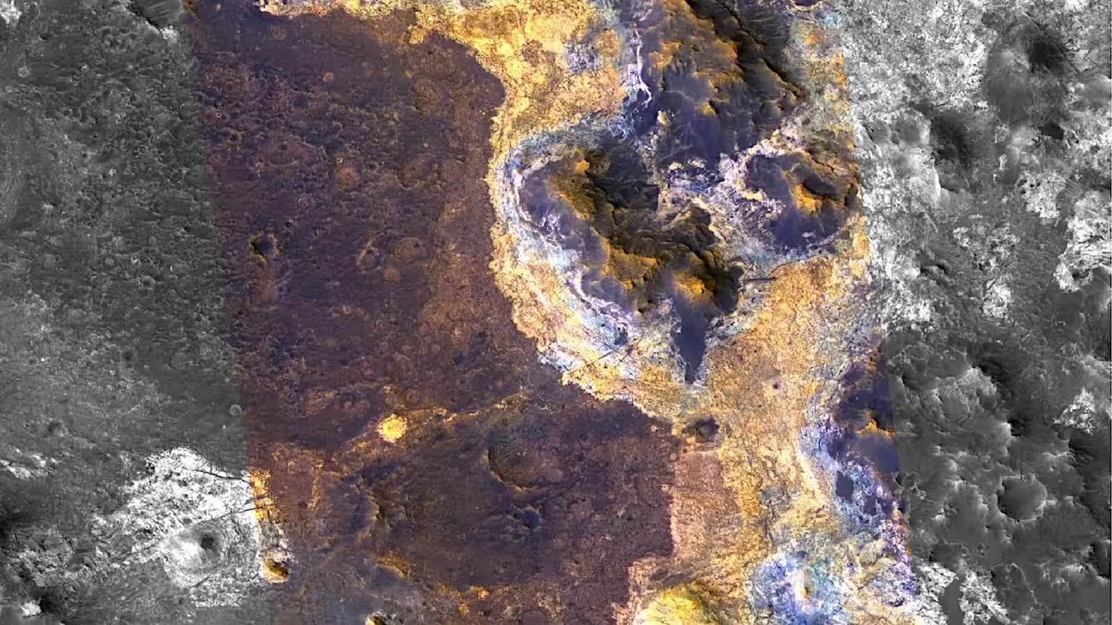
Image: ixbt.com
The Mars rover Rosalind Franklin may be heading for far more than a promising landing site. New orbiting data suggest the clay-rich ground at Oxia Planum stretches hundreds of kilometres farther than expected, tying it to a much larger wet episode in Mars' deep past – possibly even a vast ancient body of water.
This Mars clay deposits study is good news for scientists and slightly less thrilling for anyone hoping Mars was simple. Instead, the planet keeps offering the same annoying lesson: its history is messy, local, and repeated across vast distances, which is exactly why it is so interesting.
Mars clay deposits stretch from Oxia Planum to Mawrth Vallis
Researchers say the clay-bearing deposits around the planned landing zone extend all the way to Mawrth Vallis, about 300 kilometres away. Taken together, the minerals form a structure roughly 600 kilometres long, with elevation differences of more than a kilometre.
That scale matters. If the layers really formed in a single water-rich setting, the shoreline of that ancient sea would sit among the highest proposed for any model of Mars' old oceans. In other words: this was not a puddle, and probably not even a polite lake.
Recommended reading
Zinc flow battery runs for 5,128 hours
Why scientists care so much about clay
Clay minerals are prized because they form when rock interacts with liquid water and can preserve clues about the environment in which they formed. That is why Rosalind Franklin is headed to Oxia Planum in the first place: to search for signs of ancient life and to reconstruct how water behaved on early Mars.
The team says the Oxia Planum deposits are around four billion years old and appear older than similar rocks in Mawrth Vallis. That makes the landing site more than just convenient terrain; it could expose one of the earliest chapters in Mars' watery history, long before the planet dried out.
What the orbiters saw
The study drew on data from OMEGA aboard ESA’s Mars Express and CRISM on NASA’s Mars Reconnaissance Orbiter. By comparing mineral makeup and layering between the two regions, the authors found a strikingly similar structure, which points to linked geological processes rather than isolated deposits.
They also identified an ancient palaeosurface between the two main clay layers: a buried old land surface covered in impact craters before younger material sealed it away. That gap suggests a long pause in sediment buildup, followed by a shift in water chemistry that changed the minerals forming in both regions at roughly the same time.
What Rosalind Franklin can test on the ground
Orbital data are powerful, but they still leave room for competing explanations. One model says the clays formed on the floor of a huge water body; another says repeated flooding spread water across the plains from ancient underground reservoirs. After landing, Rosalind Franklin should help decide which version fits the rocks better.
The rover brings cameras, spectrometers, ground-penetrating radar, and a lab for sample analysis. Its drilling system is the real headline act: it can pull material from up to two metres below the surface, where potential biological traces are better shielded from space radiation and other surface damage.
The next phase is cartography, not drama. Scientists are still mapping the full spread of the clay-rich units, looking for more pauses in deposition and trying to pin down how long each one lasted. If those layers really record a wet Mars with intermittent bursts of activity, the rover could end up sampling not just old mud, but the remains of a planetary climate that came and went in fits and starts.

Frontier Editor
Dan is our resident futurist, covering electric mobility, space exploration, and the smart home. He's interested in atoms just as much as bits. Whether it's a new battery chemistry, a reusable rocket, or a protocol that finally makes IoT devices talk to each other, Dan breaks down the engineering that pushes humanity forward.
via ixbt.com