

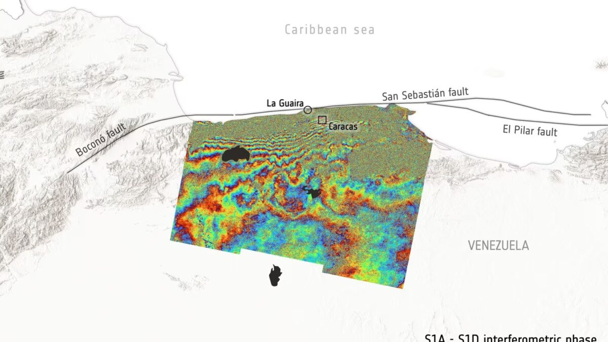
ESA’s Sentinel-1 satellites detected ground movements of up to 30 centimeters following powerful earthquakes in Venezuela, providing precise measurements of how the Earth’s crust shifted during the disaster. Using radar instead of traditional optical imaging, the satellites compared data from June 18-just days before the quakes-with measurements taken on June 25, one day after back-to-back tremors registering 7.2 and 7.5 in magnitude struck near Caracas.
Unlike optical satellites, Sentinel-1 employs radar pulses that bounce off the Earth’s surface, allowing it to sense ground shifts with centimeter-level accuracy regardless of cloud cover or time of day. This technique, known as satellite radar interferometry, generates colorful interference patterns-seen as bands around Caracas-that map changes in distance between the satellite and the ground. Each full color cycle corresponds to a particular displacement, with multiple cycles indicating significant crustal deformation.
How ESA Sentinel-1 satellites measure earthquake ground shifts
ESA linked these deformations to the San Sebastián fault zone, one of Venezuela’s major tectonic features on the northern coast. But the displacements captured are not just simple up-and-down movements. Earthquakes often cause complex multi-directional shifts, and satellites register the net change relative to their own orbits. Isolating vertical from horizontal ground motion requires integrating data from ground-based GPS and geodetic surveys.
Satellite radar interferometry in global earthquake damage assessment
Satellite radar interferometry has become a key tool for quickly assessing earthquake damage worldwide. After the 2023 Turkey-Syria quakes, similar analyses helped map fault shifts rapidly, informing emergency response. The publicly available Copernicus program data supports not only researchers but also civil protection agencies. For Venezuela, international disaster response centers and NASA’s Disaster Response Coordination System are now coordinating to combine satellite and terrestrial data. The faster these integrated insights arrive, the better authorities can identify high-risk zones prone to further damage or aftershocks.
The role of Earth observation technology in disaster management
This case highlights the growing role of Earth observation technology in real-time disaster management. As sensor networks expand and data sharing improves, expect satellite radar imaging to become an even more important resource for governments aiming to minimize earthquake impacts and prioritize aid where ground ruptures threaten communities most.